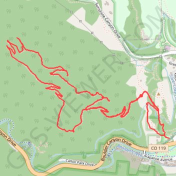
Anemone Point and Reflection Point Loop (Boulder)
Loop hike from The Peoles' Crossing to Anemone Point and Reflection Point via Red Rocks Trail, Anemone Loop Trail and Red Rocks Spur Trail in the Boulder Open Space and Mountain Parks. #Hike #Loop #Nature #Mountain #Forest #Park #Overlook
- Distance: 7.7 Km
- Elevation gain: 336 m
- Maximum elevation: 1,939 m
- Elevation loss: 338 m
- Minimum elevation: 1,660 m
- Moving time: 1 h 41 m
- Moving speed: 4.5 Km/h
- Maximum speed: 13.2 Km/h
- Total time: 2 h 4 m
- Global speed: 3.7 Km/h
- Date: 19/03/2024
Interactive map
GPS track profile
About this GPS track
Name: Anemone Point and Reflection Point Loop (Boulder) GPS track, route, trail
Start: Red Rocks Trail, Boulder County, Colorado, 80802, United States (40.01423 -105.29576)
Coordinates: 40.01421 -105.31151 40.02179 -105.29548
Other GPS tracks
Click on a GPS track to view route, its statistics and profile.