Point State to Emerald View Loop
Loop hike from Point State Park through Emerald View Park via Monongahela River, Smithfield Street Bridge, Grandview Avenue and Emerald View Trail. #Hike #Loop #Nature #Park #River #Forest #City
- Distance: 19.8 Km
- Elevation gain: 761 m
- Maximum elevation: 352 m
- Elevation loss: 761 m
- Minimum elevation: 212 m
- Moving time: 4 h 2 m
- Moving speed: 4.9 Km/h
- Maximum speed: 23.5 Km/h
- Total time: 4 h 37 m
- Global speed: 4.3 Km/h
- Date: 19/09/2021
Interactive map
GPS track profile
About this GPS track
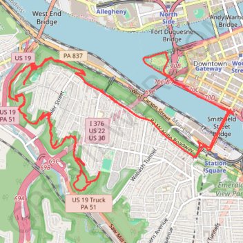
Name: Point State to Emerald View Loop GPS track, route, trail
Coordinates: 40.42772 -80.03225 40.44262 -80.00047
Other GPS tracks
Click on a GPS track to view route, its statistics and profile.