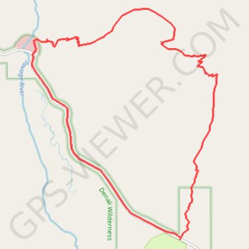
Savage Alpine Trail
Loop hike from Savage River & Mountain Vista in the Denali National Park. #Hike #Loop #Mountain #Nature #Forest #River #Park #Alaska
- Distance: 10.1 Km
- Elevation gain: 500 m
- Maximum elevation: 1,265 m
- Elevation loss: 501 m
- Minimum elevation: 788 m
- Moving time: 3 h 20 m
- Moving speed: 3.0 Km/h
- Maximum speed: 50.4 Km/h
- Total time: 3 h 50 m
- Global speed: 2.6 Km/h
- Date: 05/06/2016
Interactive map
GPS track profile
About this GPS track
Name: Savage Alpine Trail GPS track, route, trail
Start: Savage River Loop Trail, Denali, Alaska, United States (63.73949 -149.29133)
End: Savage River Loop Trail, Denali, Alaska, United States (63.73953 -149.29142)
Coordinates: 63.71702 -149.29215 63.74360 -149.24379
Other GPS tracks
Click on a GPS track to view route, its statistics and profile.
Road Trip Alaska 2018
United States > Alaska > Anchorage > Anchorage
From Anchorage.
Distance: 641.7 Km • Elevation gain: 4,791 m • Maximum elevation: 739 m