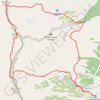
Pirin 17/08/2023 Vihren Hut - Kazana - Vihren summit - Vihre...
- Distance: 8.2 Km
- Elevation gain: 960 m
- Maximum elevation: 2,908 m
- Elevation loss: 957 m
- Minimum elevation: 1,974 m
- Moving time: 4 h 20 m
- Moving speed: 1.9 Km/h
- Maximum speed: 5.0 Km/h
- Total time: 6 h 53 m
- Global speed: 1.2 Km/h
- Date: 17/08/2023
Interactive map
GPS track profile
About this GPS track
Name: Pirin 17/08/2023 Vihren Hut - Kazana - Vihren summit - Vihre... GPS track, route, trail
Start: към пещерата, Bansko, Blagoevgrad, Bulgaria (41.75669 23.41631)
End: към пещерата, Bansko, Blagoevgrad, Bulgaria (41.75671 23.41613)
Coordinates: 41.75664 23.39662 41.77206 23.41631
Other GPS tracks
Click on a GPS track to view route, its statistics and profile.
Vihren hut - Vihren - Koncheto - Banski Sukodol - Kazana - V...
Distance: 11.8 Km • Elevation gain: 1,309 m • Maximum elevation: 2,906 m
Vihren Hut - Demyanitsa Hut
Distance: 15.5 Km • Elevation gain: 661 m • Maximum elevation: 2,588 m
Bynderishki Lakes (circular)
Distance: 7.9 Km • Elevation gain: 469 m • Maximum elevation: 2,332 m