Otley Chevin
- Distance: 8.8 Km
- Elevation gain: 238 m
- Maximum elevation: 278 m
- Elevation loss: 251 m
- Minimum elevation: 60 m
- Moving time: 2 h 44 m
- Moving speed: 3.2 Km/h
- Maximum speed: 16.6 Km/h
- Total time: 4 h 20 m
- Global speed: 2.0 Km/h
- Date: 18/04/2024
Interactive map
GPS track profile
About this GPS track
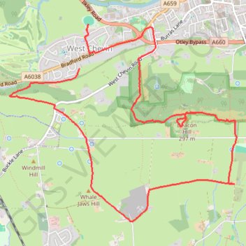
Name: Otley Chevin GPS track, route, trail
Coordinates: 53.88445 -1.72464 53.90206 -1.69017
Other GPS tracks
Click on a GPS track to view route, its statistics and profile.
Otley - Eccup Reservoir - Harewood Bank - Otley (bicycle)
United Kingdom > England > Leeds > Otley
Distance: 34.5 Km • Elevation gain: 364 m • Maximum elevation: 178 m
Otley - Eccup Reservoir - Harewood Bank - Otley (bicycle)
United Kingdom > England > Leeds > Otley
Distance: 34.9 Km • Elevation gain: 377 m • Maximum elevation: 179 m