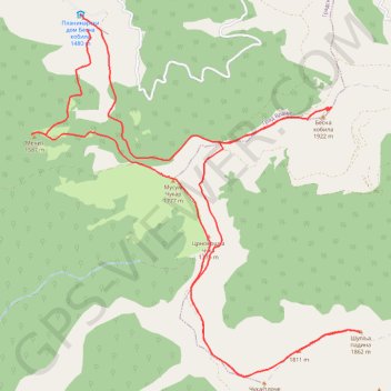
Trenutna trasa: 29 KOL 2015 09:15 001
- Distance: 20.2 Km
- Elevation gain: 943 m
- Maximum elevation: 1,909 m
- Elevation loss: 942 m
- Minimum elevation: 1,453 m
- Moving time: 4 h 53 m
- Moving speed: 4.1 Km/h
- Maximum speed: 6.9 Km/h
- Total time: 6 h 20 m
- Global speed: 3.2 Km/h
- Date: 29/08/2015
Interactive map
GPS track profile
About this GPS track
Name: Trenutna trasa: 29 KOL 2015 09:15 001 GPS track, route, trail
Coordinates: 42.50063 22.18665 42.54075 22.23604