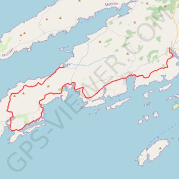
39: Dunmanus – Ballydehob (Developed with signs)
- Distance: 48.6 Km
- Elevation gain: 704 m
- Maximum elevation: 158 m
- Elevation loss: 700 m
- Minimum elevation: 0 m
Interactive map
GPS track profile
About this GPS track
Name: 39: Dunmanus – Ballydehob (Developed with signs) GPS track, route, trail
Start: Dunmanus, West Cork, Comté de Cork, Munster, P81 R928, Irlande (51.53976 -9.66440)
End: R592, Ballydehob ED, West Cork, Comté de Cork, Munster, P81 XF34, Irlande (51.56291 -9.45973)
Coordinates: 51.46328 -9.77565 51.56291 -9.45463
Other GPS tracks
Click on a GPS track to view route, its statistics and profile.
Trace IRELAND
Distance: 1,506.7 Km • Elevation gain: 13,359 m • Maximum elevation: 524 m
RT5-1 Rosslare - Kinsale
Distance: 2,860.3 Km • Elevation gain: 27,381 m • Maximum elevation: 420 m
RT5-1 Rosslare - Kinsale
Distance: 3,867.1 Km • Elevation gain: 36,115 m • Maximum elevation: 524 m
RT5-1 Rosslare - Kinsale
Distance: 1,353.5 Km • Elevation gain: 15,245 m • Maximum elevation: 420 m