TT isle of Man
- Distance: 60.7 Km
- Elevation gain: 890 m
- Maximum elevation: 426 m
- Elevation loss: 890 m
- Minimum elevation: 6 m
Interactive map
GPS track profile
About this GPS track
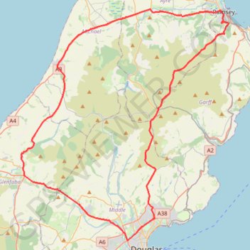
Name: TT isle of Man GPS track, route, trail
Start: Douglas Road, Kirk Michael, Michael, Île de Man (54.28108 -4.58795)
End: Douglas Road, Kirk Michael, Michael, Île de Man (54.28110 -4.58796)
Coordinates: 54.15569 -4.63307 54.32306 -4.37614
Other GPS tracks
Click on a GPS track to view route, its statistics and profile.
Douglas à Douglas Île de Man, IMN
Île de Man > Middle > Douglas
Distance: 63.8 Km • Elevation gain: 935 m • Maximum elevation: 426 m