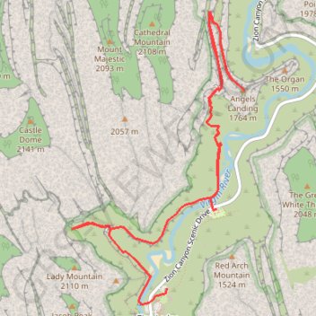
Emerald Pools, Scout Lookout and Angels Landing
Hike from Zion Lodge to Emerald Pools and Angels Landing via Virgin River, Lower Emerald Pool Trail, Lower Emerald Pool, Upper Emerald Pool, Kayenta Trail, West Rim Trail and Angels Landing Trail in the Zion Canyon and the Zion National Park. #Hike #Canyon #River #Rock #Park #Zion #Nature #Overlook
- Distance: 9.7 Km
- Elevation gain: 872 m
- Maximum elevation: 1,688 m
- Elevation loss: 869 m
- Minimum elevation: 1,302 m
- Moving time: 3 h 2 m
- Moving speed: 3.2 Km/h
- Maximum speed: 6.4 Km/h
- Total time: 3 h 24 m
- Global speed: 2.9 Km/h
- Date: 17/01/2016
Interactive map
GPS track profile
About this GPS track
Name: Emerald Pools, Scout Lookout and Angels Landing GPS track, route, trail
Coordinates: 37.25100 -112.96636 37.27597 -112.94784
Other GPS tracks
Click on a GPS track to view route, its statistics and profile.
Scout Lookout, Emerald Pools, View on the Patriarchs (Zion Canyon)
United States > Utah > Washington County > Zion Lodge
Hike in the Zion Canyon via West Rim Trail, Scout Lookout, Kayenta Trail, Upper Emerald Pool, Lower Emerald Pool, Virgin River, Sand Bench Trail and View on the Patriarchs. #Hike #Canyon #River #Nature #Rock #Mountain #Park #Zion
Distance: 16.6 Km • Elevation gain: 1,411 m • Maximum elevation: 1,711 m
Angels Landing and Emerald Pools (Zion Canyon)
United States > Utah > Washington County > Zion Lodge
Hike from West Rim Trailhead to Angels Landing and Emerald Pools via West Rim Trail, Virgin River, Scout Lookout, Kayenta Trail, Lower Emerald Pool, Middle Emerald Pool and Upper Emerald Pool in the Zion National Park. #Hike #Canyon #Zion #Nature #River #Rock #Falls
Distance: 11.2 Km • Elevation gain: 1,285 m • Maximum elevation: 1,627 m