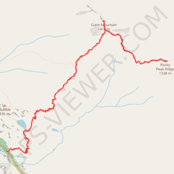
Giant Mountain and Rocky Peak Ridge
Hike from Chapel Pond to Giant Mountain and Rocky Peak Ridge via Ridge Trail, Ridge Lookout, Giant Washbowl, Roaring Brook Trail, East Trail and Giant East Slide Lookout in the Giant Mountain Wilderness and Adirondack Park. #Hike #Mountain #Nature #Forest #Lake #Park #Wilderness
- Distance: 13.1 Km
- Elevation gain: 1,336 m
- Maximum elevation: 1,387 m
- Elevation loss: 1,334 m
- Minimum elevation: 492 m
- Moving time: 5 h 8 m
- Moving speed: 2.6 Km/h
- Maximum speed: 5.2 Km/h
- Total time: 5 h 45 m
- Global speed: 2.3 Km/h
- Date: 08/07/2022
Interactive map
GPS track profile
About this GPS track
Name: Giant Mountain and Rocky Peak Ridge GPS track, route, trail
End: Ridge Trail, Town of Keene, Essex County, New York, United States (44.13841 -73.74365)
Coordinates: 44.13811 -73.74377 44.16118 -73.70478
Other GPS tracks
Click on a GPS track to view route, its statistics and profile.
Montréal - New York
Canada > Québec > Agglomération de Montréal > Montréal
Distance: 637.3 Km • Elevation gain: 4,134 m • Maximum elevation: 301 m