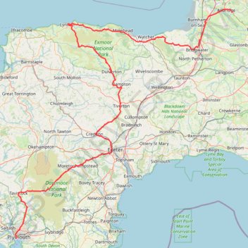
TT22 Jo11 J9/06 : Cheddar à Plymouth Ferry Terminal
- Distance: 268.2 Km
- Elevation gain: 4,170 m
- Maximum elevation: 458 m
- Elevation loss: 4,190 m
- Minimum elevation: 0 m
Interactive map
GPS track profile
About this GPS track
Name: TT22 Jo11 J9/06 : Cheddar à Plymouth Ferry Terminal GPS track, route, trail
Start: Frog Cottage, Cliff Street, Cheddar, Somerset, Angleterre, BS27 3PX, Royaume-Uni (51.27959 -2.77362)
End: Camber Road, Millbay, Plymouth, Angleterre, PL1 3EW, Royaume-Uni (50.36428 -4.15593)
Coordinates: 50.36428 -4.16458 51.28973 -2.77362
Other GPS tracks
Click on a GPS track to view route, its statistics and profile.
Tour d'Europe
France > Bretagne > Finistère > Concarneau > Landan Creis
Distance: 7,132.9 Km • Elevation gain: 44,603 m • Maximum elevation: 2,433 m
Woodland Fort paths
United Kingdom > England > Plymouth
Distance: 5.3 Km • Elevation gain: 97 m • Maximum elevation: 82 m
Tour de la petite Manche Angleterre
Royaume-Uni > Angleterre > Plymouth
Vélo. En aller simple entre Plymouth et Weymouth. #Vélo
Distance: 273.9 Km • Elevation gain: 4,094 m • Maximum elevation: 297 m
TT22 Jo10 M8/06 : Aberystwyth à Cheddar
Royaume-Uni > Pays de Galles > Ceredigion > Aberystwyth
Distance: 247.4 Km • Elevation gain: 3,874 m • Maximum elevation: 515 m