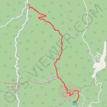
7-9-10 Staza br.10 Vlajna
- Distance: 8.7 Km
- Elevation gain: 213 m
- Maximum elevation: 1,439 m
- Elevation loss: 904 m
- Minimum elevation: 569 m
- Moving time: 2 h 16 m
- Moving speed: 3.8 Km/h
- Maximum speed: 5.7 Km/h
- Total time: 3 h 41 m
- Global speed: 2.3 Km/h
- Date: 12/09/2015
Interactive map
GPS track profile
About this GPS track
Name: 7-9-10 Staza br.10 Vlajna GPS track, route, trail
Coordinates: 42.78496 21.92270 42.82988 21.95428
Other GPS tracks
Click on a GPS track to view route, its statistics and profile.
Tour d'Europe
France > Bretagne > Finistère > Concarneau > Landan Creis
Distance: 7,132.9 Km • Elevation gain: 44,603 m • Maximum elevation: 2,433 m
De Giromagny à Sofia
France > Bourgogne-Franche-Comté > Territoire-de-Belfort > Giromagny
Distance: 1,875.9 Km • Elevation gain: 12,108 m • Maximum elevation: 1,054 m
2022_Yu
Slovenia > Ajdovščina > Žapuže
Distance: 2,457.3 Km • Elevation gain: 32,048 m • Maximum elevation: 1,950 m