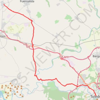
SE17-Toledo-Noves
Total: 39.4km
- Distance: 39.3 Km
- Elevation gain: 341 m
- Maximum elevation: 580 m
- Elevation loss: 306 m
- Minimum elevation: 434 m
Interactive map
GPS track profile
About this GPS track
Name: SE17-Toledo-Noves GPS track, route, trail
End: Calle Real, Novés, Castille-La Manche, 45519, Espagne (40.04561 -4.27176)
Coordinates: 39.85737 -4.27176 40.04561 -4.02277
Other GPS tracks
Click on a GPS track to view route, its statistics and profile.
EuroVelo 1 (Spain)
Espagne > Andalousie > Côte occidentale > Ayamonte
Distance: 1,355.6 Km • Elevation gain: 14,587 m • Maximum elevation: 1,320 m
Southern section — European Divide Trail
France > Auvergne-Rhône-Alpes > Drôme > Valence
Distance: 2,423.8 Km • Elevation gain: 42,375 m • Maximum elevation: 2,005 m
Eurovelo 01 Spain + Portugal
France > Nouvelle-Aquitaine > Pyrénées-Atlantiques > Hendaye
Distance: 3,107.2 Km • Elevation gain: 30,592 m • Maximum elevation: 1,503 m
1 LUCENA - MONTPELLIER
Distance: 2,964.4 Km • Elevation gain: 29,500 m • Maximum elevation: 1,048 m
1 LUCENA - MONTPELLIER
Espagne > Andalousie > Lucena
Distance: 2,964.4 Km • Elevation gain: 29,500 m • Maximum elevation: 1,048 m
Stage 26: Valence to Saint-Jean-de-Fos — European Divide Trail
France > Auvergne-Rhône-Alpes > Drôme > Valence
Distance: 2,423.8 Km • Elevation gain: 42,375 m • Maximum elevation: 2,005 m
EuroVelo 1 (Spain)
Espagne > Andalousie > Côte occidentale > Ayamonte > Pozo del Camino > Fotea
Distance: 1,349.7 Km • Elevation gain: 13,641 m • Maximum elevation: 1,320 m
SE16-Mora-Toledo
Espagne > Castille-La Manche > Mora
Distance: 38.2 Km • Elevation gain: 372 m • Maximum elevation: 741 m