Quebec - La Yourte
Randonnée pédestre. Depuis Saint-Raymond. #Randonnée
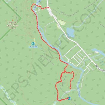
- Distance: 7.2 Km
- Elevation gain: 306 m
- Maximum elevation: 430 m
- Elevation loss: 308 m
- Minimum elevation: 199 m
Interactive map
GPS track profile
About this GPS track
Name: Quebec - La Yourte GPS track, route, trail
Coordinates: 47.04998 -71.89725 47.07560 -71.88066
Other GPS tracks
Click on a GPS track to view route, its statistics and profile.
L'étape vers rivière à Pierre via Lac Édouard
Canada > Québec > La Côte-de-Beaupré > Lac-Jacques-Cartier
Distance: 277.0 Km • Elevation gain: 3,766 m • Maximum elevation: 974 m
Boucle La Tuque et Rivière à Pierre via 411
Canada > Québec > Portneuf (MRC) > Rivière-à-Pierre
Distance: 326.1 Km • Elevation gain: 4,607 m • Maximum elevation: 554 m
Zec Batiscan-Neilson (boucle Gouat vers Fairchild)
Canada > Québec > Portneuf (MRC) > Saint-Raymond
Distance: 180.4 Km • Elevation gain: 2,784 m • Maximum elevation: 709 m
Québec - Chute Delaney
Canada > Québec > Portneuf (MRC) > Saint-Raymond
Randonnée en aller-retour depuis Saint-Raymond. #Randonnée
Distance: 7.9 Km • Elevation gain: 128 m • Maximum elevation: 232 m