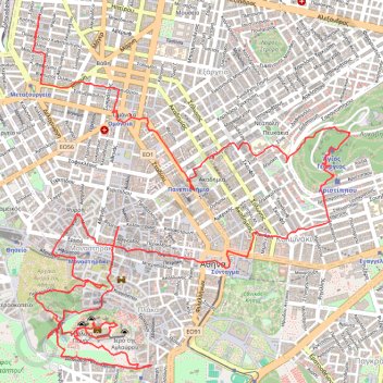
Randonnée du 28/09/2023 à 09:49
- Distance: 12.3 Km
- Elevation gain: 373 m
- Maximum elevation: 260 m
- Elevation loss: 390 m
- Minimum elevation: 64 m
- Moving time: 3 h 57 m
- Moving speed: 3.1 Km/h
- Maximum speed: 14.9 Km/h
- Total time: 8 h 17 m
- Global speed: 1.5 Km/h
- Date: 28/09/2023
Interactive map
GPS track profile
About this GPS track
Name: Randonnée du 28/09/2023 à 09:49 GPS track, route, trail
Coordinates: 37.96940 23.72159 37.98999 23.74496
Other GPS tracks
Click on a GPS track to view route, its statistics and profile.
Greek port to Athens (port)
Grèce > Épire-Macédoine occidentale > Περιφερειακή Ενότητα Θεσπρωτίας > Igoumenítsa
Distance: 488.0 Km • Elevation gain: 7,322 m • Maximum elevation: 791 m
Randonnée du 27/09/2023 à 13:15
Grèce > Attique > Περιφερειακή Ενότητα Κεντρικού Τομέα Αθηνών > Athènes
Distance: 6.4 Km • Elevation gain: 84 m • Maximum elevation: 115 m
Randonnée du 28/09/2023 à 19:34
Grèce > Attique > Περιφερειακή Ενότητα Κεντρικού Τομέα Αθηνών > Athènes
Distance: 0.6 Km • Elevation gain: 9 m • Maximum elevation: 97 m
Randonnée du 27/09/2023 à 09:15
Grèce > Attique > Περιφερειακή Ενότητα Κεντρικού Τομέα Αθηνών > Athènes
Distance: 7.3 Km • Elevation gain: 118 m • Maximum elevation: 106 m