Fire Wave (Valley of Fire State Park)
Hike to Fire Wave in the Valley of Fire State Park via the Fire Wave Trail. #Hike #Nature #Rock #Desert #Park
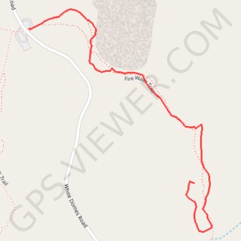
- Distance: 1.4 Km
- Elevation gain: 30 m
- Maximum elevation: 621 m
- Elevation loss: 72 m
- Minimum elevation: 562 m
- Moving time: 57 m 20 s
- Moving speed: 1.5 Km/h
- Maximum speed: 2.2 Km/h
- Total time: 1 h 30 m
- Global speed: 1.0 Km/h
- Date: 25/02/2024
Interactive map
GPS track profile
About this GPS track
Name: Fire Wave (Valley of Fire State Park) GPS track, route, trail
Start: Fire Wave Trail, Clark County, Nevada, United States (36.48833 -114.52869)
End: Fire Wave Trail, Clark County, Nevada, United States (36.48383 -114.52270)
Coordinates: 36.48243 -114.52869 36.48890 -114.52207
Other GPS tracks
Click on a GPS track to view route, its statistics and profile.
Fire Wave, White Domes Slot Canyon and Kaolin Slot Canyon Loop (Valley of Fire)
United States > Nevada > Clark County
Loop hike in the Valley of Fire State Park via Fire Wave Trail, Kaolin Slot Canyon, White Domes Slot Canyon, Prospect Trail, White Domes, Seven Wonders Trail, Crazy Hill, Thunderstorm Arch and Fire Cave. #Hike #Loop #Nature #Rock #Desert #Park #Canyon
Distance: 5.9 Km • Elevation gain: 142 m • Maximum elevation: 624 m