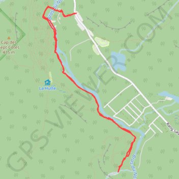
Québec - Chute Delaney
Randonnée en aller-retour depuis Saint-Raymond. #Randonnée
- Distance: 7.9 Km
- Elevation gain: 128 m
- Maximum elevation: 232 m
- Elevation loss: 129 m
- Minimum elevation: 199 m
Interactive map
GPS track profile
About this GPS track
Name: Québec - Chute Delaney GPS track, route, trail
Coordinates: 47.05269 -71.89748 47.07565 -71.87850
Other GPS tracks
Click on a GPS track to view route, its statistics and profile.
Quebec - La Yourte
Canada > Québec > Portneuf (MRC) > Saint-Raymond
Randonnée pédestre. Depuis Saint-Raymond. #Randonnée
Distance: 7.2 Km • Elevation gain: 306 m • Maximum elevation: 430 m