Marine de Vincendo
Interactive map
GPS track profile
About this GPS track
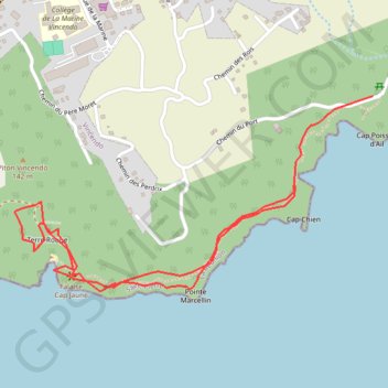
Name: Marine de Vincendo GPS track, route, trail
End: Chemin du Port, Saint-Joseph, Saint-Pierre, La Réunion, 97480, France (-21.37816 55.67669)
Coordinates: -21.38363 55.66590 -21.37816 55.67669
Other GPS tracks
Click on a GPS track to view route, its statistics and profile.
🚶 Trace ,boucle du tour de La Réunion par La Montagne
France > La Réunion > Saint-Denis
🌍 Tag : #FranceTourisme #OfficeTourisme #RandonnéesFrance 🚶 Par - Bons plans en France ,Outre-mers : https://www.google.com/maps/d/embed?mid=1VJ6s4u13Cn0OaTEAOgdmNOh9tNxCCnno
Distance: 300.4 Km • Elevation gain: 6,413 m • Maximum elevation: 1,209 m
2jLangevinbassevallee
France > La Réunion > Saint-Joseph > Langevin
Distance: 48.4 Km • Elevation gain: 2,635 m • Maximum elevation: 2,353 m