La Printanière - Équeurdreville-Hainneville
Interactive map
GPS track profile
About this GPS track
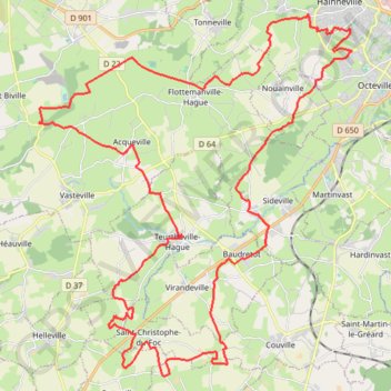
Name: La Printanière - Équeurdreville-Hainneville GPS track, route, trail
Coordinates: 49.54423 -1.78931 49.64510 -1.65483
Other GPS tracks
Click on a GPS track to view route, its statistics and profile.
GR 223 Tour du Cotentin (2021)
France > Normandie > Eure > Berville-sur-Mer
Randonnée en Normandie sur le GR 223 autour du Cotentin à travers l'Eure, le Calvados et la Manche de Berville-sur-Mer au Mont-Saint-Michel.
Distance: 650.7 Km • Elevation gain: 6,685 m • Maximum elevation: 149 m
Tour d'Europe
France > Bretagne > Finistère > Concarneau > Landan Creis
Distance: 7,132.9 Km • Elevation gain: 44,603 m • Maximum elevation: 2,433 m
Sentier Cotentin - Cherbourg vers Mont-Saint-Michel
France > Normandie > Manche > La Hague > Urville-Nacqueville > La Rivière
Distance: 231.7 Km • Elevation gain: 2,584 m • Maximum elevation: 128 m
10km du Cotentin 2024
France > Normandie > Manche > La Hague > Vauville > La Terrasse
La Hague / Cherbourg-en-Cotentin
Distance: 10.0 Km • Elevation gain: 18 m • Maximum elevation: 181 m
MICHEL LAIR
France > Normandie > Manche > Cherbourg-en-Cotentin
Michel Lair
Distance: 18.7 Km • Elevation gain: 231 m • Maximum elevation: 146 m
Nouveau parcours
France > Normandie > Manche > Helleville
Helleville -Héauville 50 Manche
Distance: 14.8 Km • Elevation gain: 177 m • Maximum elevation: 138 m
GR22 - De Cherbourg à Flamanville
France > Normandie > Manche > Cherbourg-en-Cotentin
Randonnée entre Cherbourg-Octeville et Flamanville. #Randonnée
Distance: 70.2 Km • Elevation gain: 1,477 m • Maximum elevation: 131 m
GR223 - Cherbourg à Coutances
France > Normandie > Manche > Cherbourg-en-Cotentin
Randonnée entre Cherbourg-Octeville et Coutances. #Randonnée
Distance: 201.4 Km • Elevation gain: 2,106 m • Maximum elevation: 138 m
RAF 2022 / 2600 n1 News
France > Hauts-de-France > Pas-de-Calais > Le Touquet-Paris-Plage
Distance: 2,594.8 Km • Elevation gain: 39,725 m • Maximum elevation: 2,766 m
Rando cap de la Hague
France > Normandie > Manche > La Hague > Urville-Nacqueville > La Rivière
Randonnée entre Urville-Nacqueville et Baubigny. #Randonnée
Distance: 79.8 Km • Elevation gain: 1,378 m • Maximum elevation: 130 m
Itinéraire de Nemours à Nemours
France > Centre-Val de Loire > Loiret > Bromeilles > Bainvilliers
Distance: 1,576.4 Km • Elevation gain: 8,536 m • Maximum elevation: 238 m
1 - sidevillaise-18525602-1710246214-973
France > Normandie > Manche > Sideville > Village de l'Église
La Sidevillaise (substitution)
Distance: 5.3 Km • Elevation gain: 52 m • Maximum elevation: 51 m
Randonnée de Cherbourg à Portbail par le GR 223
France > Normandie > Manche > Cherbourg-en-Cotentin
Randonnée sur sentier du littoral à travers la Manche de Cherbourg à Portbail via Equeurdreville, Urville-Nacqueville, Hameau aux Fèvres (Greville-Hague), Digulleville, Herqueville, Biville, Les Pieux, Surtainville, Baubigny, Barneville-Carteret et Barneville-Carteret. #Randonnée #GR223 #Normandie #Manche #Mer #Nature
Distance: 110.6 Km • Elevation gain: 2,100 m • Maximum elevation: 131 m
1 - etape-3-tdn-2024-parcours (1)
France > Normandie > Manche > Coutances
Etape 3 16 mars 2024
Distance: 137.1 Km • Elevation gain: 1,831 m • Maximum elevation: 157 m
Relais des 4 Châteaux - Tourlaville
France > Normandie > Manche > Cherbourg-en-Cotentin
Distance: 51.3 Km • Elevation gain: 1,150 m • Maximum elevation: 175 m
Track-Saint Jean de Luz
Belgique > Hainaut > Ath > Lessines
Distance: 1,192.3 Km • Elevation gain: 9,493 m • Maximum elevation: 486 m
Track-Saint de Luz retour
France > Nouvelle-Aquitaine > Pyrénées-Atlantiques > Saint-Jean-de-Luz
Distance: 1,133.5 Km • Elevation gain: 6,888 m • Maximum elevation: 257 m
GR223 De Tourlaville à Portbail (Manche)
France > Normandie > Manche > Cherbourg-en-Cotentin
Randonnée entre Cherbourg-Octeville et Portbail. #Randonnée
Distance: 110.2 Km • Elevation gain: 2,026 m • Maximum elevation: 131 m
Enduro Kid de Vasteville 2024
France > Normandie > Manche > Héauville
Spéciale
Distance: 1.8 Km • Elevation gain: 42 m • Maximum elevation: 139 m
Martinvast 2024
France > Normandie > Manche > Martinvast > Les Rosées
parcours
Distance: 7.4 Km • Elevation gain: 116 m • Maximum elevation: 128 m
Flamanville (Rando des caps 2022) 56km
France > Normandie > Manche > Flamanville > Marcanville
Distance: 56.7 Km • Elevation gain: 979 m • Maximum elevation: 141 m
12 km belle étoile 2023 indice B-16175928
France > Normandie > Manche > Cherbourg-en-Cotentin
Distance: 12.3 Km • Elevation gain: 214 m • Maximum elevation: 117 m
8 km belle étoile 2023 indice B-15964591
France > Normandie > Manche > Cherbourg-en-Cotentin
Distance: 7.6 Km • Elevation gain: 163 m • Maximum elevation: 78 m
Teurthéville 2024
France > Normandie > Manche > Teurthéville-Hague
circuit Teurthéville 2024 avec signaleurs v1
Distance: 10.5 Km • Elevation gain: 143 m • Maximum elevation: 138 m