Sirzenich/Sirzenich/Sirzenich
<html xmlns:fo="http://www.w3.org/1999/XSL/Format" xmlns:msxsl="urn:schemas-microsoft-com:xslt">,
<head>,
<META http-equiv="Content-Type" content="text/html">,
<meta http-equiv="content-type" content="text/html; charset=UTF-8">,
</head>,
<body style="margin:0px 0px 0px 0px;overflow:auto;background:#FFFFFF;">,
<table style="font-family:Arial,
Verdana,
Times;font-size:12px;text-align:left;width:100%;border-collapse:collapse;padding:3px 3px 3px 3px">,
<tr style="text-align:center;font-weight:bold;background:#9CBCE2">,
<td>Sirzenich</td>,
</tr>,
<tr>,
<td>,
<table style="font-family:Arial,
Verdana,
Times;font-size:12px;text-align:left;width:100%;border-spacing:0px; padding:3px 3px 3px 3px">,
<tr>,
<td>FID</td>,
<td>0</td>,
</tr>,
<tr bgcolor="#D4E4F3">,
<td>Id</td>,
<td>0</td>,
</tr>,
<tr>,
<td>weg_bez_</td>,
<td>Sirzenich</td>,
</tr>,
<tr bgcolor="#D4E4F3">,
<td>laenge</td>,
<td>11329</td>,
</tr>,
</table>,
</td>,
</tr>,
</table>,
</body>,
</html>
- Distance: 11.3 Km
- Elevation gain: 299 m
- Maximum elevation: 364 m
- Elevation loss: 299 m
- Minimum elevation: 189 m
Interactive map
GPS track profile
About this GPS track
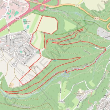
Name: Sirzenich/Sirzenich/Sirzenich GPS track, route, trail
Coordinates: 49.75642 6.59152 49.77033 6.61934
Other GPS tracks
Click on a GPS track to view route, its statistics and profile.
Rhin par la rive gauche
Suisse > Uri > Korporation Ursern > Andermatt
Vélo. En aller simple entre Andermatt et Hoek van Holland. Suisse centrale. #Vélo #SuisseCentrale #Alpes #Montagne #Nature
Distance: 1,454.5 Km • Elevation gain: 6,868 m • Maximum elevation: 2,047 m
Tour d'Europe
France > Bretagne > Finistère > Concarneau > Landan Creis
Distance: 7,132.9 Km • Elevation gain: 44,603 m • Maximum elevation: 2,433 m
Saint-Jacques-de-Compostelle - Trier - Metz
Allemagne > Rhénanie-Palatinat > Landkreis Trier-Saarburg > Newel
Distance: 123.3 Km • Elevation gain: 1,774 m • Maximum elevation: 407 m
Eurovelo 15 - Entire Route
Pays-Bas > Hollande-Méridionale > Hoek van Holland
Distance: 1,453.6 Km • Elevation gain: 8,277 m • Maximum elevation: 2,047 m
Stage 14: Frederikshavn to Aars — European Divide Trail
Danemark > Jutland du Nord > Frederikshavn
Distance: 2,225.3 Km • Elevation gain: 28,686 m • Maximum elevation: 1,389 m
Rhin par la rive gauche
Suisse > Uri > Korporation Ursern > Andermatt
Distance: 1,454.2 Km • Elevation gain: 6,254 m • Maximum elevation: 2,050 m
RAF 2022 / 2600 n1 News
France > Hauts-de-France > Pas-de-Calais > Le Touquet-Paris-Plage
Distance: 2,594.8 Km • Elevation gain: 39,725 m • Maximum elevation: 2,766 m
Eurovelo 15 - Strasbourg Rotterdam
France > Grand Est > Bas-Rhin > Strasbourg
comment ...
Distance: 891.7 Km • Elevation gain: 2,140 m • Maximum elevation: 146 m
Eurovéloroute-15-Route-du-Rhin
Suisse > Uri > Korporation Ursern > Andermatt
Distance: 1,499.0 Km • Elevation gain: 6,966 m • Maximum elevation: 2,046 m
Merlimont (62155), Pas-de-Calais, Hauts-de-France, France - Nice (06000-06300), Alpes-Maritimes, France
France > Hauts-de-France > Pas-de-Calais > Merlimont
Distance: 2,326.3 Km • Elevation gain: 11,884 m • Maximum elevation: 524 m
Eurovelo 15 - Entire Route
Pays-Bas > Hollande-Méridionale > Hoek van Holland
Distance: 1,454.1 Km • Elevation gain: 7,752 m • Maximum elevation: 2,050 m
Trace
France > Normandie > Seine-Maritime > Saint-Laurent-de-Brèvedent
Distance: 2,147.5 Km • Elevation gain: 23,741 m • Maximum elevation: 1,618 m
Megève - Ohain
France > Auvergne-Rhône-Alpes > Haute-Savoie > Megève
<p>De Route de Rochebrune, 74120 Megève, Auvergne-Rhône-Alpes, France<br/> À Chemin du Moulin, 1380 Ohain, Belgique</p> <p>Routage Moto - le plus joli</p>
Distance: 794.9 Km • Elevation gain: 9,132 m • Maximum elevation: 1,357 m
Itinéraire de Ham-sur-Heure-Nalinnes à Le Bonhomme
Belgique > Hainaut > Thuin > Ham-sur-Heure
Distance: 455.3 Km • Elevation gain: 4,455 m • Maximum elevation: 953 m
Marche-en-Famenne
Belgique > Luxembourg > Marche-en-Famenne > Marche-en-Famenne
<p>From Rue Dupont 46, 6900 Marche-en-Famenne, Belgium<br/> To Avenue de France, 6900 Marche-en-Famenne, Belgium</p> <p>Routing Motor - nicest</p>
Distance: 2,843.5 Km • Elevation gain: 28,856 m • Maximum elevation: 1,078 m
Eurovelo 15 - Strasbourg Rotterdam
France > Grand Est > Bas-Rhin > Strasbourg
Distance: 891.7 Km • Elevation gain: 2,104 m • Maximum elevation: 146 m
Eurovelo 15 - Entire Route
Pays-Bas > Hollande-Méridionale > Hoek van Holland
Distance: 1,454.1 Km • Elevation gain: 7,752 m • Maximum elevation: 2,050 m
Jour 19 / 28 Juin 2022 (Final)
Distance: 882.9 Km • Elevation gain: 8,008 m • Maximum elevation: 952 m
Riethoven naar Oostenrijk
Netherlands > North Brabant > Riethoven > Eind
Distance: 922.1 Km • Elevation gain: 13,629 m • Maximum elevation: 1,897 m
Vuisternens-devant-Romont à Bonn
Suisse > Fribourg > District de la Glâne > Sommentier > La Magne
Distance: 645.1 Km • Elevation gain: 7,408 m • Maximum elevation: 1,159 m