Maragondon - Bonifacio Shrine and Eco-Tourism Park
#Hike
- Distance: 11.1 Km
- Elevation gain: 113 m
- Maximum elevation: 37 m
- Elevation loss: 113 m
- Minimum elevation: 12 m
Interactive map
GPS track profile
About this GPS track
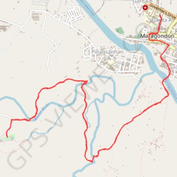
Name: Maragondon - Bonifacio Shrine and Eco-Tourism Park GPS track, route, trail
Coordinates: 14.26012 120.71786 14.27642 120.73658
Other GPS tracks
Click on a GPS track to view route, its statistics and profile.
Maragondon - Mount Kalanggaman
Philippines > Cavite > Maragondon > Garita B
#Hike
Distance: 28.3 Km • Elevation gain: 790 m • Maximum elevation: 559 m